Why?
Cycling the Blue Ridge Parkway is on the “bucket list” of formidable rides for serious cyclists.
The Blue Ridge Parkway runs across the spine of the Blue Ridge mountains linking the Shenandoah Park in northern Virginia to the Great Smokey’s Park in North Carolina. This elevation map provides a hint of the ups and downs associated with cycling the Parkway.
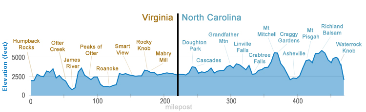
Of note is Mt. Mitchell in North Carolina. At 6,684 feet of elevation, it is the highest peak in the United States east of the Mississippi. Climbing Mt. Mitchell is also on a cyclist’s bucket list and something Rusty and I accomplished in June. What’s fascinating is the weather on Mt. Mitchell, just 32 miles from our starting point that day near Asheville, NC. When we departed Asheville at 7:00 a.m., it was sunny and going to a high in the mid-’80s. When we got to the top of Mt. Mitchell, it was in the low 50s, wind gusts of over 30 mph, and fogged in. Sweat-soaked from the tough climb, before we began the descent we grabbed a large park map from a tear-off pad in the gift shop and shoved it into our jerseys and jackets to shield us from the wind and cold.

Our sag driver, Mary Ann McCain, snapped this photo of me as I began the descent.
Whether we make the side climb from the Parkway to the top of Mt. Mitchell on our ride will be a game-day decision.